|
CASOAR : Introduction
Initialy designed by Thierry Souriot (CNRS 2007-2012).
Web Manager Yannick GUEHENNEUX
Please contact : Y.Guehenneux for technical questions,
and J.L.Froger for scientific questions.
Last update 2019/06/19 (all dates are in YYYY/MM/DD format).
Introduction -
Acknowledgements -
User's guide -
Know bugs -
History -
Access and User Charter
|
 |
 Aims Aims |
CASOAR
is a tool dedicated to sorting, selecting, visualizing and sharing
large-radar-images-databases. It includes a set of processing components
and a WEB interface.
It was initially designed for the co-investigators and ESA research
project partners to access SAR and InSAR images, but it could easily be
upgraded for various satellite image types such as SPOT, LANDSAT, ASTER,
etc.
Currently, CASOAR integrates radar data (~ 1200 RAW/SLC images &
~ 3000 interferograms) acquired in the framework of 6 main projects
(ESA AOE.746, AOE. 857, C1P.2899, AOALO.3622, AO for Turkey 2446,
DLR LAN.O237).
|
| Data Processing |
Firstly the new data is extracted, formated, processed
and recorded of new data onto the database.
This part of CASOAR is mainly written in C and shell scripts and also
uses external software and libraries such as
NEST (ESA),
DIAPASON (Altamira©),
ImageJ,
ImageMagik,
Manip_Raster
, etc...
At this step, particular attention was given to achieve maximum
automation of the procedures so that the updating and maintenance
of the database requires minimal operator intervention.
|
| Web Interface |
The second component of
CASOAR consists of a WEB interface
developed in PHP, MySQL and Google API. This interface allows partial
or total access to the database by means of a login/password connection
with different levels of permissions.
|
| Project, Group, User and Security |
CASOAR security is ensured by means of dividing the database
into projects, visible only by authorised groups and users.
Each user has his own login/password allowing access to
specific projects and specific data or images in the project. The user
connection history is recorded and is visible only to the database administrator.
Login/Password are provided on request (use the Registeration button on the connection page). The registeration validation procedure may take few
days since it is not fully automated.
Anonymous access is possible but with more restrited rights,
such as lower resolution and tagged images, and only images
are only available for the OI2 project.
|
| Data Visualisation |
The images selected can be presented either
in a parameters table, a location map or via different levels of quick
looks. Clicking on a given quick look opens it in a new window with a
higher resolution and a list of relevant information.

Table |
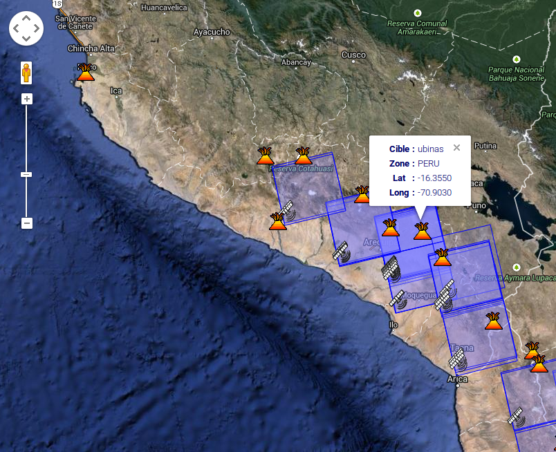
Map Google API |
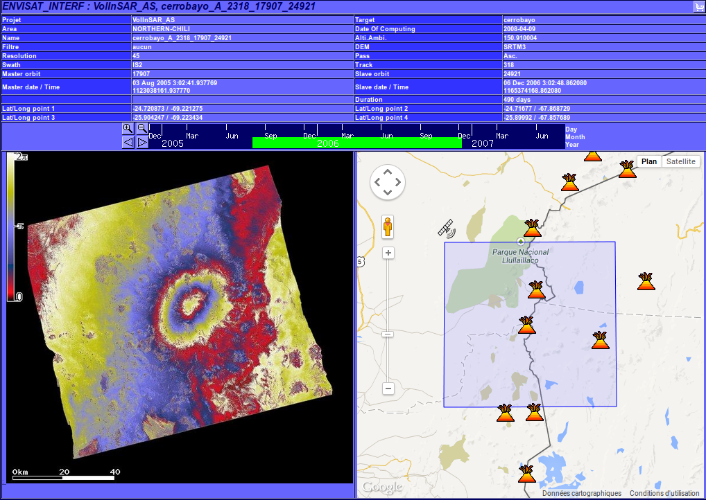
Image preview |
|
| Automatic functionalities: |

- Network survey and downloading of data (e.g. : Doris orbit on FTP server)
- Data and metadata extraction and conversion from original files
- Database update and notification email
- Interferograms computation, using an automated procedure based on the DIAPASON software (Altamira©)
- Physical and/or network backup
|
| Available data types : |
Available : (numbers are in real time) |
Planned : |
- ERS SAR 1 & 2 raw : 287 images
- ERS SAR 1 & 2 interferrogram : 0 images
- RADARSAT 1 & 2 SLC : 85 images
- RADARSAT 1 & 2 interferogram : 118 images
- ENVISAT ASAR SLC : 887 images
- ENVISAT interferogram : 5044 images
- ENVISAT MERIS : 107 images
|
- ALOS PALSAR SLC : 754 images
- ALOS PALSAR interferogram : 778 images
- TerraSAR-X SLC : 373 images
- TerraSAR-X interferogram : 1172 images
- COSMO-SKYMED SLC : 275 images
- COSMO-SKYMED interferogram : 2828 images
- Information
|
- DEM
- SPOT
- Aerial photography
|
|
| Utilities : |
IMPORT/EXPORT of selection parameters
CASOAR saves active selection parameters for each user at
the end of his session and automatically restores them at the beginning
of the next user login. It is also possible to save the selection
parameters at any time during the session in a CASOAR file (.kzr).
CASOAR files can then be shared with other users.
DESIRABLES
Another way to register a selection is by adding the data into
the Desirables icon. The Desirables function is accessible both at the TABLE
selector level and at the image preview level. It can be used by the
co-investigators to request full resolution data which will then be automatically
downloaded by our FTP server.
|
| Future improvements |
We are planning to integrate new data format and
new function into CASOAR, for example, dynamic statistic
analysis of interferogram subsets.
|
|
| Acknowledgements |
The following people have contributed to the production of the data displayed in CASOAR :
- J.L. Froger, S. Byrdina, and Th. Souriot in various project.
- F. Albino, K. Gonzales, and D. Remy for ENVISAT and ERS ASAR interferograms in the VolInSAR_AS project.
- F. Ranvier for ERS ASAR interferograms in the VolInSAR_ET project.
- P. Tinard for ENVISAT ASAR interferograms in the OI2 project.
- D. Tolluoglu for ENVISAT and ERS ASAR interferograms in the VolInSAR_TK project.
Scientific programs which have provided us with satellite data used in CASOAR :
- ERS and ASAR-ENVISAT images of South America were provided by the European Space Agency through project ENVISAT-AO #857 and Category-1 #2899.
- ERS and ASAR-ENVISAT images of Etna were provided by the European Space Agency through project ERS-AO3 #999257, ENVISAT-AO #857 and Category 1 #1125.
- ERS and ASAR-ENVISAT images of Turkey were provided by the European Space Agency through project AO for Turkey #2446.
- ASAR ENVISAT images of Piton de La Fournaise were provided by the European Space Agency through project ENVISAT-AO #746 and ALOS ADEN #3622.
- MERIS ENVISAT images of Piton de La Fournaise were provided by the European Space Agency through project ENVISAT-AO #746
- PALSAR ALOS images of Piton de La Fournaise were provided by the European Space Agency and JAXA through project ALOS ADEN #3622
- TerraSAR-X images of Piton de La Fournaise were provided by DLR to CNES through project KALIDEOS - BD-ISLE DLR LAN #O237.
- RADARSAT-2 images of Piton de La Fournaise were provided by CSA-MDA through project ASC SOAR #2314
We thank the ANR, INSU, IRD, FONDECYT/CONICYT, and OPGC for funding support.
|
|