Observatoire de Physique
du Globe de Clermont-Ferrand
OI²
Observatoire InSAR de l'Océan Indien


OI² - A CLOSELY MONITORED VOLCANOIV - The data.The radar images used to produce the S.O. data are supplied free, or at reduced rates, by a number of Space Agencies within the framework of different projects (table 1).
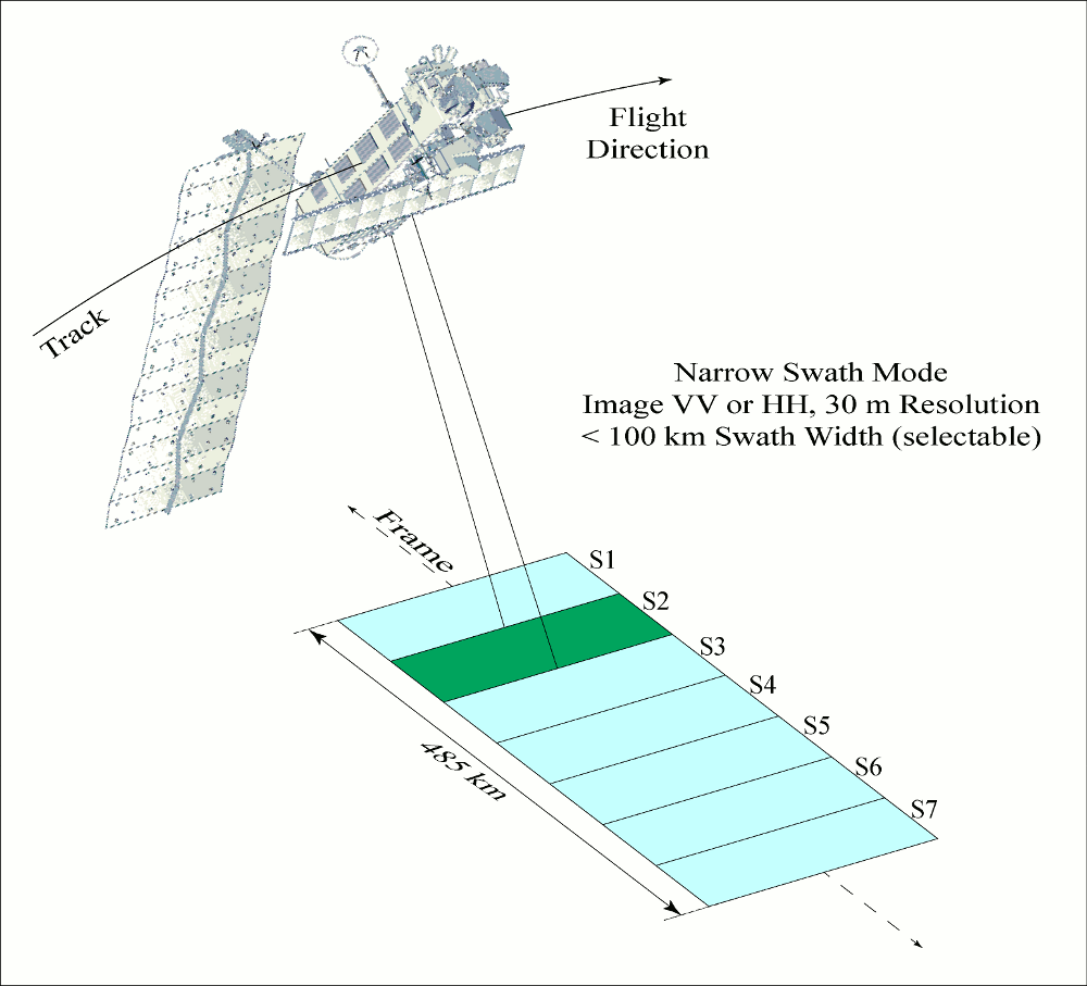
The ASAR-ENVISAT data, obtained from the European Space Agency (ESA), comprise the greatest proportion of our database (around 430 images have been acquired since 2003, see table 1). They are synthesised radar images in which the phase is preserved (Single Look Complex, SLC, IMS-1P format, V/V polarisation). We submit our requests for images to the ESA roughly once every trimester using the EOLISA software. We request images in several swaths (lines-of-sight, figure 1), on both ascending and descending paths, which allows us to obtain not only a regular temporal coverage for Reunion Island, but also a broad diversity of radar image angles.
Given the isolated location of Reunion Island in the middle of the Indian Ocean, image requests from other users are rare. This reduces the risk of conflicting programming, and guarantees us a high percentage of success in our requests for images. Only those images acquired in the same swath can be combined to produce an interferogram. The minimum reiteration period for a line-of-sight in a single swath is 35 days for ASAR-ENVISAT. The period covered by an ASAR interferogram is thus in multiples of 35 days. Interferometric combinations covering relatively short periods (35, 70, 105 days) are systematically calculated, while combinations covering longer periods are calculated only as required. ALOS-PALSAR data in L-Band are also acquired. These data are obtained free from the ESA in the framework of an ALOS-ADEN project (table 1). Since 2006, 26 images have been acquired, mainly on ascending paths, in single and double polarisation. 71 interferograms have been created from these images. Since 2008, our InSAR database on the Piton de la Fournaise has also incorporated TerraSAR-X images in X-Band (SLC Stripmap) acquired routinely and free-of-charge from the DLR (Deutsches Zentrum für Luft- und Raumfahrt) within the framework of the Kalideos CNES program (table 1). Programming demands are made by T. Rabaute (Technical Officer for the CNES) in order to guarantee regular coverage (roughly every 33 days) of both ascending and descending paths. During volcanic activity we request data every 11 days. Since December 2008 a total of 32 TSX images have been acquired, from which we have produced 25 interferograms. We should soon start receiving CSOMOSkyMed images in X-Band (CSK) (table 1), which will also be supplied regularly and free-of-charge. RADARSAT-2 images in C-Band, acquired individually within the framework of an SOAR project, complete the database (table 1). The extensive archives we have established since 2003 mean that Reunion Island is one of the global reference sites in terms of time-series InSAR measurements. Currently, the only data provided by the S.O. are the interferograms we have calculated. These interferograms are available for viewing and downloading on our CASOAR database. The SLC images are the property of the various Space Agencies, and are not available for downloading. In the near future we plan to make available the interferometric coherence images and the unwrapped inerferograms, and, in the more distant future, displacement maps.
|
 |
 |
 |
 |
Home page - Contact - Credits & Legal - Last update : 2013/11/07