| Since 1986, the ENG has followed
several targets:
|
 |
La Fournaise is a basaltic volcano which effusive activity is predominant. During phases of several years activity, about 2 eruptions occurs every year. Most of them take place among the main NE-SW fracture zone which cuts the Enclos Fouqué caldera.
This volcano is a valuable test site to implement EM monitoring systems and to develop EM methods.
| Since 1986, the ENG has followed
several targets:
|
|
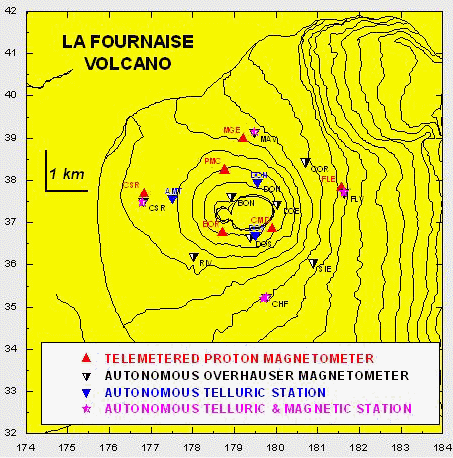
After 1985 a magnetic network of up to eight telemetered stations recording the total field intensity, was setup on the volcano.
The network belongs to the networks driven by the French Volcanic Observatories of IPGP (http://volcano.ipgp.jussieu.fr:8080/) and is maintained by the Volcanic Observatory of La Fournaise.
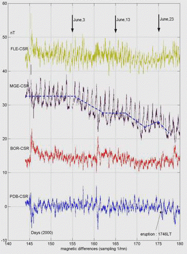
Magnetic signals, up to several nanoTeslas (nT) appears in the weeks to hours preceding the eruptions. The amplitude is generally emphasized during the displacement of the magma towards the ground surface.
|
|
|
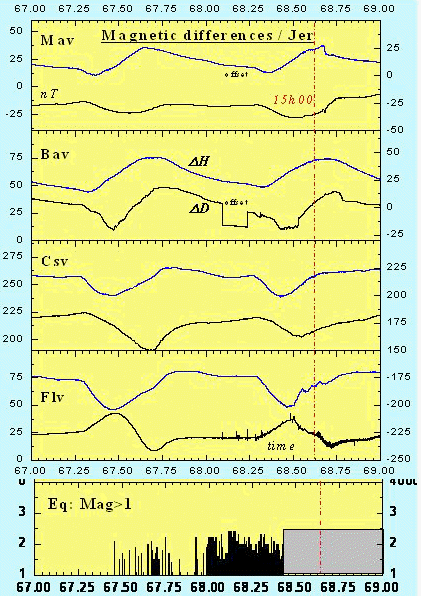
| The June 23, 2000 eruption.
Daily variations of the differences between the total magnetic field
recorded at several stations and CSR, taken as reference station.
|
In 2003 the telemetered network was reduced to three stations.
Several kind of networks have been progressively implemented in order to develop an integrated approach of magnetic, electric and EM phenomena related to the volcanic activity.
A tens of stations recording the total field intensity has been located in the Enclos Fouqué caldera, set along two rings around the summit crater Bory and Dolomieu.
|
|
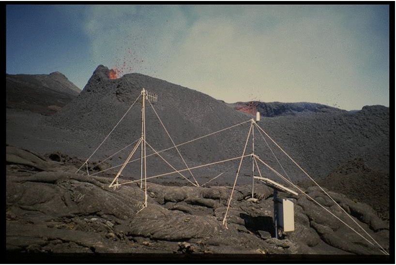
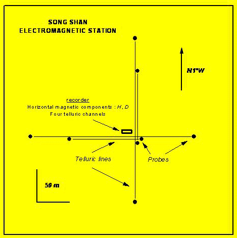
Magnetic station on the northern flank of La Fournaise. The total field is measured every minute. |
Up top 7 stations are operating on the volcano. These stations record the electric field in two horizontal North-South and East-West directions, when the topography permits it. Some of the stations are associated with the recording of the components of the magnetic field.
Such network is devoted to look for electric signals in the ULF band (Period (T) > 2 sec).
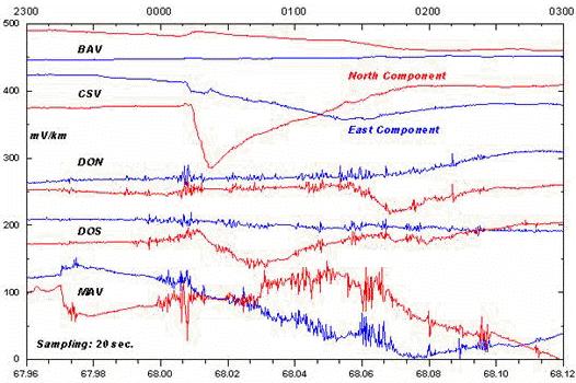
Oscillations up to several tens of mV:km, and of a few minutes duration, were observed in the weeks preceding the March 9, 1998 eruption.The SP signals as due to electrokinetic effects generated by fluid flow in cracks opened by the stress field changes.
|
|
|
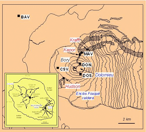
| Location of the electric network. Dashed contours represent the lava flow of the March 8, 1998 eruption. | Electric signals recorded at 5 stations during the night preceding the March 8, 1998 eruption (day 68; Zlotnicki et al., 2001). |
Two EM networks are set on La Fournaise. One has the aim to identify lmagnetic and electric signals in the ULF band and the other is focused on signal recognition in the ELF band (frequency > 10 Hz).
ULF band
The stations record both the horizontal components of the electric and magnetic field
Magnetic changes of a few nT in amplitude are observed before an eruption, but no oscillatory signals as in the electric field, are yet observed.
|
|
|
| Sketch of an EM station. Both horizontal components of the magnetic and electric fields are recorded. | Magnetic signals in the horizontal magnetic differences during the night preceding the March 8, 1998 eruption (day 68). |
ELF band
The objective is to enlarge the field of investigations on EM signals to a higher frequency domain; the ELF one (frequency > 100 Hz).
Refer to DEMETER MISSION.
The researches follow two goals:
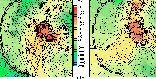
In 1992, the hydrothermal system has been well-recognized by Self-potential (SP) surveys in the Enclos Fouqué caldera where positive anomalies up to 1.8 Volt are related to upward ground fluid flow. Positive anomalies also extend along the main fracture zone. The amplitude and the location of anomalies change with time with the volcanic activity
|
|
|
Comparison of the SP anomalies in Enclos Fouqué caldera between 1992 and 2001 (Zlotnicki and Nishida, 2003) |
|
|
|
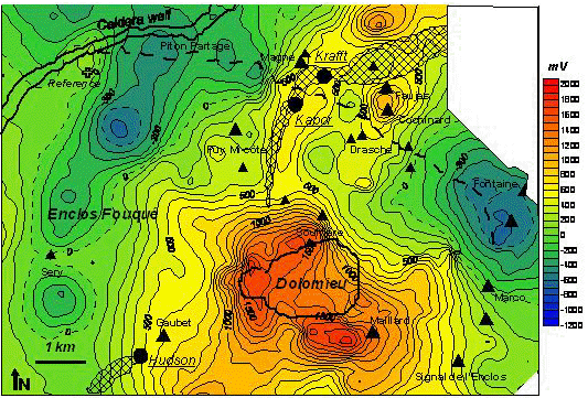
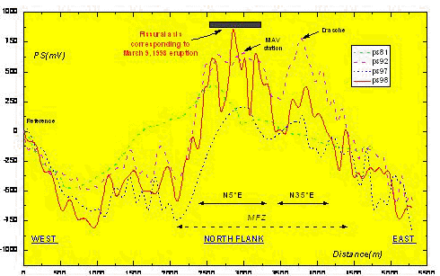
| Self-Potential mapping on the northern flank of the volcano (after Michel and Zlotnicki, 1998). Triangles correspond to major cones or craters. Heavy dash line is the path used to re-survey the SP anomalies on the northern flank | Self-Potential anomaly along the profile described in figure 3, made in 1981 (estimated), 1992, 1997, and on March 11, 1998. The zero potential is taken at the western end of the profile (Zlotnicki et al., 2001).. |
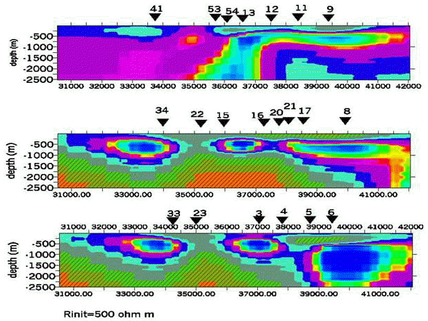
Audiomagnetotelluric soundings were performed in Enclos Fouqué caldera and in its vicinity as well as outside the caldera on the north-eastern flank.
Low resistive structures take place on the western and eastern flanks of the summit. Ahigh resisitve zone stands below the summit.
The main fracture zone is well observed on west-east slices.
|
|
|
Iso-resistivity contours along three West-East slices : on the northern flank, on the summit and on the southern flank of the summit |
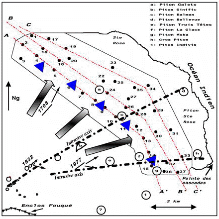
Outisde of the caldera, the audiomagnetotelluric soundings express the spliting of the main fracture zone in several branches.
|
|
|
Large arrows indicate the intrusive axes found by the audiomagnetoitelluric surveys (black points) |